455296-1 Florida Heartland Regional Trail - Highlands County
Website for Entire Project: https://floridaheartlandregionaltrail.com/
Project Details
About
In 2024, FDOT completed the Collier to Polk Trail Master Plan to evaluate a paved, multiuse trail for bicyclists and pedestrians from Collier County to Polk County. The Master Plan included preliminary routing alternatives and associated recommendations to develop the project as a regionally significant trail within the Florida Shared-Use Non-motorized (SUN) Trail Network. The Master Plan set the stage to conduct PD&E studies for what is now called the Florida Heartland Regional Trail.
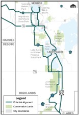
The Highlands County Feasibility Study will develop and evaluate the trail alignments identified in the Master Plan extending from the Glades County line to the Hardee County line. The map shows the potential trail alignments through Highlands County, Lake Placid, and the City of Sebring. The alignments generally follow United States 27, State Road (S.R.) 70, S.R. 66, and other county and local roads possibly connecting to Devane Park, Stuart Park, the Lake Placid Historical Society, Archbold Biological Station, Platt Branch Wildlife Environmental Area, Lake June-in-Winter State Park, Max Long Recreation Complex, Veterans Beach Park, Circle Park, the City of Sebring Pier and Beach, and Highlands Hammock State Park.
Public Involvement
Public involvement is an integral part of the PD&E Study process. FDOT will engage interested parties in the study process and there will be opportunities for public comment, including a public information meeting. You may also submit comments or questions about this project at any time during the study, by using the "Send a comment" button to the right.
If you are interested in being added to the mailing list to receive study information for the Highlands County segment or any of the other segments of the trail, please provide your contact information at: Get Involved – The Florida Heartland Regional Trail.
FAQs
What is a regionally significant trail?
The Florida Heartland Regional Trail has been identified and prioritized as a regionally significant trail by the Florida Greenways and Trails Council [Section 260.0142(4)(c), FS]. That means it is recognized for its potential to:
- Cross multiple counties
- Attract national and international visitors
- Provide opportunities for economic and ecotourism development
- Showcase the value of wildlife areas, ecology, and natural resources
- Serve as a main corridor for critical links and trail connectedness
Why are multiple feasibility studies being conducted?
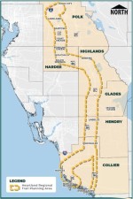
Because of the project’s extensive length, feasibility studies are being conducted for each county that is part of the Florida Heartland Regional Trail planning area: Collier, Hendry, Glades, Highlands, Hardee, and Polk. Each study will follow its own schedule to evaluate the Master Plan’s preliminary alternatives, assess environmental impacts, and solicit public input.
What is a feasibility study?
A feasibility study considers potential social, economic, and environmental effects, as well as constructability and costs, to determine project viability. The study helps FDOT determine how the project will move forward to future phases. The starting point for the Florida Heartland Regional Trail’s feasibility studies will be the Collier to Polk Trail Master Plan’s preliminary routing alternatives.
Data Collection
The first major work effort is the collection of all available data pertaining to the study corridor including existing and planned infrastructure, existing and future land uses, drainage patterns, and environmental resources.
Public Kickoff Newsletter
A public kickoff newsletter is mailed to introduce the project to the public and provide an opportunity to view and comment on the project’s need and objectives.
Feasibility Study Report
The Feasibility Study report will document results of the public outreach efforts; development and evaluation of planning level trail alignments; and potential issues or impacts that could eliminate potential alignments from further consideration.
Contact Information
| PD&E Project Manager |
|---|
|
Cris Schooley, PE
(407) 768-3227
Cris.schooley@dot.state.fl.us
|
| For Media Inquiries Only |
|
fdot-d1comm@dot.state.fl.us
|